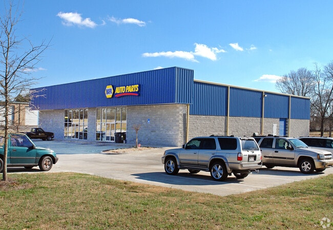
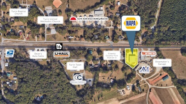
Property Record
5079 E Highway 16, Senoia, GA 30276

NEARBY LISTINGS FOR SALE OR LEASE
Property Detail
5079 E Highway 16
Atlanta-Sandy Springs-Roswell, GA
Byron Griffith
148-1149-007
BUILDING/1.24 AC LL 149 LD 1
Storebuilding
Coweta
X
Georgia
13077C0259D
149
2025
1.24 AC
2025
Coweta County
170502
Atlanta
10,000 SF
DEMOGRAPHICS near 5079 E Highway 16
1 Mile
3 Mile
5 Mile
2024 Total Population
759
6,507
24,101
2029 Population
854
7,284
26,959
Pop Growth 2024-2029
+ 12.52%
+ 11.94%
+ 11.86%
Average Age
42
41
40
2024 Total Households
277
2,330
8,450
HH Growth 2024-2029
+ 12.27%
+ 12.10%
+ 11.96%
Median Household Inc
$85,670
$80,149
$94,187
Avg Household Size
2.70
2.80
2.80
2024 Avg HH Vehicles
2.00
2.00
2.00
Median Home Value
$332,317
$305,454
$321,617
Median Year Built
2000
1995
1998
Nearby Places
Map Layers
Map Styles
 Street
 Aerial
- Restaurants
- Banks
- Shops
- Fitness
- Groceries
PUBLIC TRANSPORTATION
AIRPORT
Hartsfield - Jackson Atlanta International
DRIVE
WALK
Distance
Hartsfield - Jackson Atlanta International
47 min
34.0 mi
SALE & LEASE HISTORY
LISTING DATE
SALE/LEASE

Oct 30, 2020
For Sale
Nearby Properties
Address
Land Use
TOTAL SIZE
Lot Size
Zoning
Address
Land Use
TOTAL SIZE
Lot Size
Zoning
166,866 SF
85.16 AC
R1
Address
Land Use
TOTAL SIZE
Lot Size
Zoning
112,934 SF
108.27 AC
R1
Address
Land Use
TOTAL SIZE
Lot Size
Zoning
93,907 SF
24.25 AC
R1
Address
Land Use
TOTAL SIZE
Lot Size
Zoning
784 SF
517.26 AC
RFA
Address
Land Use
TOTAL SIZE
Lot Size
Zoning
18,136 SF
7.89 AC
R1
Address
Land Use
TOTAL SIZE
Lot Size
Zoning
467.02 AC
RFA
Address
Land Use
TOTAL SIZE
Lot Size
Zoning
4,965 SF
62.66 AC
R1
Address
Land Use
TOTAL SIZE
Lot Size
Zoning
14,198 SF
14.68 AC
R1
Address
Land Use
TOTAL SIZE
Lot Size
Zoning
10,540 SF
9.66 AC
RFA
Address
Land Use
TOTAL SIZE
Lot Size
Zoning
6,572 SF
5.17 AC
R1
Address
Land Use
TOTAL SIZE
Lot Size
Zoning
8,641 SF
3.31 AC
M
Address
Land Use
TOTAL SIZE
Lot Size
Zoning
93.01 AC
RFA
Address
Land Use
TOTAL SIZE
Lot Size
Zoning
269.94 AC
RFA
Address
Land Use
TOTAL SIZE
Lot Size
Zoning
8,118 SF
10 AC
RFA
Address
Land Use
TOTAL SIZE
Lot Size
Zoning
12,780 SF
2.38 AC
001
Address
Land Use
TOTAL SIZE
Lot Size
Zoning
19,400 SF
5 AC
M
Address
Land Use
TOTAL SIZE
Lot Size
Zoning
3,734 SF
55.81 AC
R1
Address
Land Use
TOTAL SIZE
Lot Size
Zoning
156.65 AC
RFA
Address
Land Use
TOTAL SIZE
Lot Size
Zoning
104.06 AC
RFA
Address
Land Use
TOTAL SIZE
Lot Size
Zoning
9,786 SF
7.36 AC
R1
Address
Land Use
TOTAL SIZE
Lot Size
Zoning
9,504 SF
2.03 AC
R1
Address
Land Use
TOTAL SIZE
Lot Size
Zoning
18,268 SF
16.99 AC
C
Address
Land Use
TOTAL SIZE
Lot Size
Zoning
48.77 AC
001
Address
Land Use
TOTAL SIZE
Lot Size
Zoning
938 SF
93.35 AC
R1
Address
Land Use
TOTAL SIZE
Lot Size
Zoning
3,290 SF
0.63 AC
R1
Address
Land Use
TOTAL SIZE
Lot Size
Zoning
101.52 AC
RFA
Address
Land Use
TOTAL SIZE
Lot Size
Zoning
68.36 AC
R1
Address
Land Use
TOTAL SIZE
Lot Size
Zoning
106.58 AC
R1
Address
Land Use
TOTAL SIZE
Lot Size
Zoning
65.18 AC
RFA
The World's #1 Commercial Real Estate Marketplace
Connect with us
© 2025 CoStar Group
The information above has been obtained from sources believed reliable. While we do not doubt its accuracy we have not verified it and make no guarantee, warranty or representation about it. It is your responsibility to independently confirm its accuracy and completeness. Any projections, opinions, assumptions, or estimates used are for example only and do not represent the current or future performance of the property. The value of this transaction to you depends on tax and other factors which should be evaluated by your tax, financial, and legal advisors. You and your advisors should conduct a careful, independent investigation of the property to determine to your satisfaction the suitability of the property for your needs.